Log in
All resources
Create a design
6,986 Free Images of Image Editing
maps from the earth and its inhabitants, vol. iv
maps from the earth and its inhabitants, vol. vii
maps from the earth and its inhabitants, vol. xiv
maps from the earth and its inhabitants, vol. xiii
maps from the earth and its inhabitants, vol. viii
maps from the earth and its inhabitants, vol. xvi
maps from the earth and its inhabitants, vol. xviii
dictionnaire populaire illustré de décembre-alonnier-tome 2
auguste trichon
maps from the earth and its inhabitants, vol. ii
maps from the earth and its inhabitants, vol. ii
st malo
maps from the earth and its inhabitants, vol. vii
provinces of japan
maps of the districts of the canton of bern
biel/bienne (administrative district)
maps from the earth and its inhabitants, vol. xiv
old maps of sydney
maps from the earth and its inhabitants, vol. iv
old maps of the firth of forth
maps from the earth and its inhabitants, vol. xiv
1870s maps of australia
maps from the earth and its inhabitants, vol. v
maps of the north atlantic
maps from the earth and its inhabitants, vol. xiii
maps indicating exploration
maps from the earth and its inhabitants, vol. iv
maps of the humber estuary
maps from the earth and its inhabitants, vol. viii
temperature maps
maps from the earth and its inhabitants, vol. xvi
19th-century maps of mexico city
maps of borders of ecuador
1870s maps of ecuador
maps from the earth and its inhabitants, vol. iv
1870s maps of scotland
maps from the earth and its inhabitants, vol. iv
maps of guildford
maps from the earth and its inhabitants, vol. iv
19th-century maps of the english channel
maps from the earth and its inhabitants, vol. xii
sete cidades
maps from the earth and its inhabitants, vol. xvi
maps of central america
maps from the earth and its inhabitants, vol. iv
maps of rochester, kent
maps from the earth and its inhabitants, vol. iv
old maps of exeter
maps from the earth and its inhabitants, vol. vi
pyatigorsk
maps from the earth and its inhabitants, vol. xiii
maps of journeys
mining in south africa
maps of vaal river
maps from the earth and its inhabitants, vol. xiii
1870s maps of africa
maps from the earth and its inhabitants, vol. iv
lowestoft
maps from the earth and its inhabitants, vol. iv
old maps of swansea
maps from the earth and its inhabitants, vol. iv
milford haven
maps from the earth and its inhabitants, vol. iv
huddersfield
le désert et le monde sauvage
lemuridae
maps from the earth and its inhabitants, vol. iv
old maps of bristol
maps from the earth and its inhabitants, vol. v
skaptar-jokull
maps from the earth and its inhabitants, vol. vii
1870s maps of japan
the lands of scripture (1879)
architecture bl
maps from the earth and its inhabitants, vol. vii
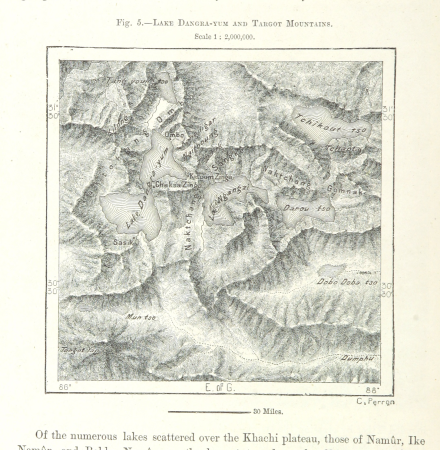
targot mountains
maps from the earth and its inhabitants, vol. xiii
mount kenya
maps from the earth and its inhabitants, vol. iv
19th-century maps of cornwall
maps from the earth and its inhabitants, vol. iv
1870s maps of scotland
maps from the earth and its inhabitants, vol. xiv
exploration of australia
maps from the earth and its inhabitants, vol. viii
maps of the mekong
19th-century maps of sierra leone
maps of rivers of sierra leone
illiteracy in france
education in france
maps from the earth and its inhabitants, vol. iii
population density maps of germany
maps from the earth and its inhabitants, vol. iv
sewers in london
maps from the earth and its inhabitants, vol. viii
ghats
dictionnaire populaire illustré de décembre-alonnier-tome 2
historical images of the cour carrée
dictionnaire populaire illustré de décembre-alonnier-tome 2
historical images of the hippodrome de longchamp
dictionnaire populaire illustré de décembre-alonnier-tome 2
historical images of the hippodrome d'auteuil
illustrations from alberti - della pittura e della statua, milano, 1804
giuseppe benaglia
dictionnaire populaire illustré de décembre-alonnier-tome 2
historical images of gex (ain)
maps from the earth and its inhabitants, vol. iii
1870s maps of switzerland
maps from the earth and its inhabitants, vol. iv
old maps of hastings, england
maps from the earth and its inhabitants, vol. xvi
maps of the history of mexico
maps from the earth and its inhabitants, vol. iv
19th-century double hemisphere world maps
maps from the earth and its inhabitants, vol. iv
bathymetric maps of the north sea
maps of rivers of south sudan
sobat river
maps from the earth and its inhabitants, vol. xi
maps indicating exploration
maps from the earth and its inhabitants, vol. xvii
french louisiana
maps from the earth and its inhabitants, vol. xi
1870s maps of tunisia
maps from the earth and its inhabitants, vol. xvii
maps of native american tribal territories
maps from the earth and its inhabitants, vol. vii
19th-century maps of korea
maps from the earth and its inhabitants, vol. iv
portskewett
maps from the earth and its inhabitants, vol. iv
maps of balmoral castle
maps from the earth and its inhabitants, vol. x
lake tana
maps from the earth and its inhabitants, vol. iv
old maps of windsor
maps from the earth and its inhabitants, vol. vii
1870s maps of china
maps from the earth and its inhabitants, vol. iv
cirencester
maps from the earth and its inhabitants, vol. iv
old maps of the isle of arran
maps from the earth and its inhabitants, vol. xviii
maps of the indigenous peoples of south america
maps from the earth and its inhabitants, vol. iv
maps of tides
maps from the earth and its inhabitants, vol. xv
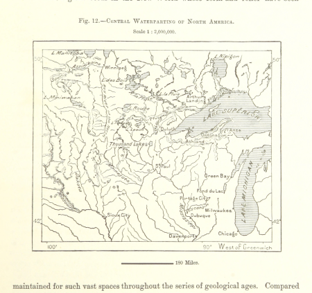
hydrological maps of the united states
maps from the earth and its inhabitants, vol. viii
maps of the mekong
maps from the earth and its inhabitants, vol. xiv
1870s maps of indonesia
maps from the earth and its inhabitants, vol. iv
1870s maps of london
maps from the earth and its inhabitants, vol. iv
old maps of dover, kent
maps from the earth and its inhabitants, vol. xviii
old maps of valparaíso
maps from the earth and its inhabitants, vol. iv
public transport maps of london
maps from the earth and its inhabitants, vol. xiii
old maps of luanda
maps from the earth and its inhabitants, vol. x
hannek
maps from the earth and its inhabitants, vol. iv
eddystone rocks, devon
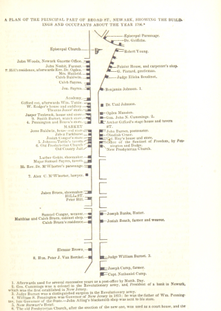
historical collections of the state of new jersey (1852)
maps of newark, new jersey
maps from the earth and its inhabitants, vol. vi
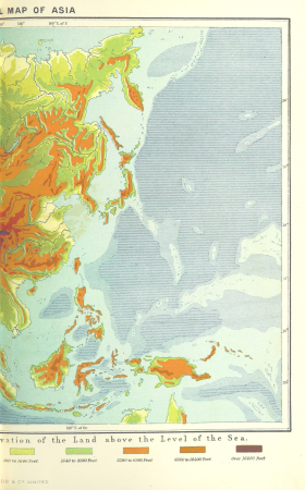
topographic maps of asia
maps from the earth and its inhabitants, vol. vii
linguistic maps of chinese languages
maps from the earth and its inhabitants, vol. xiv
1870s maps of indonesia
maps from the earth and its inhabitants, vol. xi
roads in tunisia
maps from the earth and its inhabitants, vol. iii
maps of the sava watercourse system
maps from the earth and its inhabitants, vol. ix
population density maps of the ottoman empire
fashion and costumes from the british library mechanical curator collection
illustrations by william small
maps from the earth and its inhabitants, vol. iv
queensferry crossing
maps from the earth and its inhabitants, vol. xvii
old maps of washington, d.c.
maps from the earth and its inhabitants, vol. viii
precipitation maps
maps from the earth and its inhabitants, vol. xvi
ethnographic maps of north america
maps from the earth and its inhabitants, vol. v
ringkjøbing
maps from the earth and its inhabitants, vol. xviii
1870s maps of peru
maps from the earth and its inhabitants, vol. vi
charles eugène perron
maps from the earth and its inhabitants, vol. iv
maps of falmouth, cornwall
maps from the earth and its inhabitants, vol. iv
old maps of leeds
maps from the earth and its inhabitants, vol. iv
old maps of sheffield
maps from the earth and its inhabitants, vol. xvi
jorullo
maps from the earth and its inhabitants, vol. iv
precipitation maps
maps from the earth and its inhabitants, vol. vii
yarlung tsangpo
maps from the earth and its inhabitants, vol. vii
charles eugène perron
2301 - 2400 of 6,986
Next page
/ 70